There are many disciplines in surveying. A surveyor during their career may decide to specialise in a particular discipline or may gain experience in all disciplines. The core disciplines of surveying are:
Land surveying (also known as Cadastral Surveying)
Land surveying involves measuring and determining property boundaries. Property boundaries are the basis for all property transactions, including buying, selling, mortgaging and leasing. A secure and strong property market requires certainty in the location of property boundaries. The location of property boundaries and knowledge of matters that may affect land ownership requires specialised training.
Registered land surveyors (cadastral surveyors) are the only surveyors in NSW who are legally able to carry out boundary surveys and represent details of property boundaries on plans or prepare subdivision and certain types of lease plans.
Engineering surveying
Engineering surveyors are generally engaged in the building and civil construction industries. These surveyors undertake measurements and place marks to ensure construction works are built in accordance with the approved design plans. They may be found working on construction sites setting out works such as buildings, roads, bridges, tunnels and various other forms of infrastructure.
Mining surveying
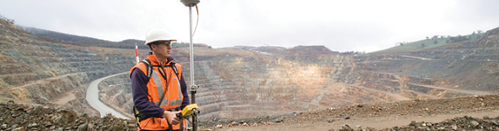
Mining surveyors are involved in the planning, construction and operation of various types of mines. These mines may be open cut or underground. Types of mines include coal, metalliferous and mineral sands. Each of these types of mining requires specialised input by a skilled mining surveyor. Activities of a mining surveyor can include setting out of drill patterns, excavations and conveyors, locating underground roadways and voids, taking of measurements for volume calculations, monitoring of ground movement, land management and preparing statutory mine plans. In NSW mine surveyors are registered to ensure there is a level of competence commensurate with ensuring compliance with the statutory requirements and mine safety.
Mining Surveyors Registered in NSW are the only surveyors who are legally able to carry out mining surveys and represent details of mining survey and mine workings on plans prepared for the purposes of the Work Health and Safety (Mines and Petroleum Sites) Act 2013.
Hydrographic (Bathymetric) surveying
Hydrographic surveying involves undertaking measurements under the surface of the sea, harbours and rivers and on the adjacent shores. There measurements are used to prepare charts of waterways and the sea for use by ships and boats to ensure a safe passage and for the design of infrastructure such as docks and jetties in ports and harbours. Using sonar scanners they are able to provide a picture of the sea bed without needing to get their feet wet and enabling the discovery of shipwrecks and other objects lost at sea.
Geodetic surveying
Geodetic surveyors are involved with undertaking very precise measurements to determine the shape and size of the world and track the movement of continents. Their measurements are used in the monitoring of sea level rise, earthquakes, and the tracking of satellites. Geodetic surveyors are involved in the development of coordinate systems and datums which are used in the production of maps and plans.
Aerial (Photogrammetry and remote sensing)
Photogrammetry and remote sensing involves taking measurements of the world via photography or other wavelength bands such as infrared or ultraviolet. Measurements may come from sources such as terrestrial or aerial photography or satellite imagery. Photogrammetry and remote sensing is used to map large areas and determine changes in the world over time
Topographic (Detail/Tachymetry)
A Detail Survey is about defining the location and heights of any number and variety of features on a site. Topographical plans can show contours along with the physical features located. This type of survey is regularly used when designing for roads, buildings, extensions and other new infrastructure. They can be carried out by all types of surveyors, however it should be noted that only Registered Land (Cadastral) Surveyors are legally able to depict details of cadastral boundaries on detail plans.
Notes
There are different levels of Surveyor, generally differentiated by the level of tertiary education, with some areas of surveying requiring higher levels of education and postgraduate study:
- Student of Surveying
- Assistant
- Technician
- Graduate
- Registered Surveyor
Allied professionals who often work closely with surveyors in areas where location is of interest are geographic information systems (GIS) / spatial professionals. However, there are also Surveyors who work in other industries and professions, whose skills and experience are different to surveyors who work in the spatial/measurement field, even though they share the title of Surveyor:
- Marine/Ship Surveyor – Vessel inspections and classification
- Quantity Surveyor – Building estimator
- Health/Building Surveyor – Historically these surveyors worked for Local Government (Councils) as building inspectors, but can now also be found it private practice as certifiers
- Asbestos Surveyor - An asbestos surveyor is a person who has sufficient training, qualifications, knowledge, experience and ability to sample and identify asbestos, has sufficient knowledge of the tasks required and the risks the work will involve, is independent of parties involved in repair or demolition work and is able to work within a quality management system.